Field Trip Descriptions
The Blackfoot Tour
Conserving the natural resources and rural lifestyle of the Blackfoot Watershed
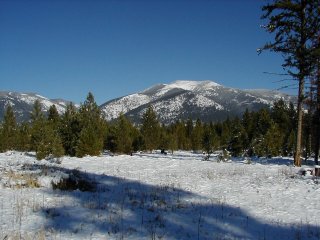 |
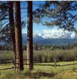
Ovando Mountain, Blackfoot Community
Conservation Area, photo courtesy of Caroline Byrd |
The Blackfoot Challenge is a landowner-based group that coordinates management of the Blackfoot River, its
tributaries, and adjacent lands. It is organized locally and known nationally as a model for preserving the
rural character and natural beauty of a watershed. Although its charter dates to 1993, Blackfoot landowners
have played an instrumental stewardship role since the late 1970’s. Today, the Challenge is comprised of private
landowners, federal and state land managers, local government officials, and corporate landowners. Together they
work on community-based resource stewardship in the valley through building trust and partnerships.
The Challenge is exploring the development of a 5,600-acre Blackfoot Community Conservation Area south of Ovando
Mountain. The concept originated as a part of the Blackfoot Community Project—a locally-driven conservation effort
developed by the Blackfoot Challenge in partnership with The Nature Conservancy to guide the future ownership and
management of approximately 88,000 acres of Plum Creek Timber Company lands in the Blackfoot.
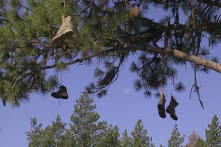 |
The Boot Tree, a local tradition, located on the way to Ovando Mountain,
photo courtesy of Bruce Andre |
The 5,600-acre conservation area is located at the southern end of the Bob Marshall and Scapegoat Wilderness Areas
and north of the nationally-renowned Blackfoot River. Formerly owned by Plum Creek Timber Company, the area
encompasses an important transition zone between national forest and productive valley bottoms, with lush riparian
and wetland areas and important wildlife habitat. The community values associated with the area are extremely rich
with a rural tradition of ranching, livestock grazing, timber harvest, and recreational activities including hunting,
horseback riding, hiking, snowmobiling and skiing.
As part of the Blackfoot Community Project, The Nature Conservancy purchased the 5,600 acres south of Ovando
Mountain in January 2004. The Nature Conservancy will hold title to the land until the Blackfoot Challenge develops
a community-based plan for ownership and management.
The Blackfoot Challenge will host the Blackfoot Valley Tour, which will include a site visit to the 5,600-acre
Blackfoot Community Conservation Area in addition to other key sites that demonstrate the cooperative programs
and projects of the Blackfoot Challenge and its partners. Tour participants will discuss important steps leading
to acquisition of the community conservation area, community involvement, and strategies and challenges to
developing a plan for ownership and management. The Challenge looks forward to brainstorming with participants
about project successes and challenges in other landscapes.
For more information, please see www.blackfootchallenge.org.
"Blackfoot conservation effort wins award, $100,000 grant" The Missoulian, July 10, 2006
View a map of the Blackfoot Challenge
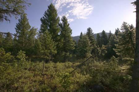 |
Low Elevational Timberlands Characterize the Blackfoot Community Conservation
Area, photo courtesy of Bruce Andre |
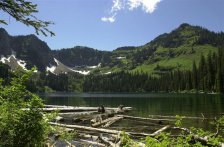
Swan Valley Tour
 Swan Valley residents have been working with the Forest Service, Trust for Public Land, Plum Creek
Timberlands, wildlife agencies, and others on a conservation strategy to protect lands the timber
company is selling. Plum Creek owns approximately 80,000 acres in the Swan Valley. The lands are
prized for their timber productivity, scenic vistas, high quality recreation opportunities and
wildlife habitat for native species, including grizzly bears and bull trout. The community wants
to protect forests and wildlife, maintain a timber-based economy and have access for recreation
and traditional uses such as firewood gathering and huckleberry picking. The heavily forested
Swan Valley lies between the Mission Mountains Wilderness to the west and the Swan Range and
Bob Marshall Wilderness to the east. The Swan River flows north through the valley and is a
major tributary of the Flathead River. The valley is divided in a square-mile checkerboard
pattern, complicating holistic management. The Forest Service, Plum Creek and the State of Montana
manage land in the checkerboard. The private residences are scattered along the Swan River and the
highway. Residential development is increasing and land use is changing as a result of timberland
divestment. Increased residential development threatens the valley’s rural way of life. The Swan
Valley tour will include sites already acquired by the Forest Service, lands soon to be protected,
and lands residents would like to conserve for community ownership and management, due to their
timber productivity, wildlife habitat, ecological significance and social values. Community leaders
will be on hand to describe how citizens have been involved in the overall conservation strategy and
discuss the issues and opportunities related to timberland divestment and acquisition of lands for
community benefit.
Swan Valley residents have been working with the Forest Service, Trust for Public Land, Plum Creek
Timberlands, wildlife agencies, and others on a conservation strategy to protect lands the timber
company is selling. Plum Creek owns approximately 80,000 acres in the Swan Valley. The lands are
prized for their timber productivity, scenic vistas, high quality recreation opportunities and
wildlife habitat for native species, including grizzly bears and bull trout. The community wants
to protect forests and wildlife, maintain a timber-based economy and have access for recreation
and traditional uses such as firewood gathering and huckleberry picking. The heavily forested
Swan Valley lies between the Mission Mountains Wilderness to the west and the Swan Range and
Bob Marshall Wilderness to the east. The Swan River flows north through the valley and is a
major tributary of the Flathead River. The valley is divided in a square-mile checkerboard
pattern, complicating holistic management. The Forest Service, Plum Creek and the State of Montana
manage land in the checkerboard. The private residences are scattered along the Swan River and the
highway. Residential development is increasing and land use is changing as a result of timberland
divestment. Increased residential development threatens the valley’s rural way of life. The Swan
Valley tour will include sites already acquired by the Forest Service, lands soon to be protected,
and lands residents would like to conserve for community ownership and management, due to their
timber productivity, wildlife habitat, ecological significance and social values. Community leaders
will be on hand to describe how citizens have been involved in the overall conservation strategy and
discuss the issues and opportunities related to timberland divestment and acquisition of lands for
community benefit.
Visit the Swan Valley Conservation website.
"Power council gives Montana $6 million. Money to buy land in Swan Valley" Spokesman Review, July 10, 2006
"Swan Valley conservation plan finalized" The Daily Interlake, February 17, 2006
Plum Creek Land Divestment Update
|